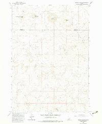
1964 Map of Market Lake NE
USGS Topo · Published 1983About this map
Big Grassy Butte and Little Grassy Butte rise prominently out of this high-desert landscape, defining a terrain shaped by volcanic activity and arid conditions. Mapped in the mid-1960s, the area straddles the boundary between Fremont County and Jefferson County, showing a sparsely developed region primarily accessible by a Jeep Trail. The placement of numerous wells suggests a critical reliance on groundwater for any agricultural or livestock activity in this eastern Idaho territory. Landmarks like Sheepherder Monument Butte and Gerber Butte serve as primary navigational points in a landscape characterized by isolation, while Little Grassy Ridge marks the southern extent of the survey area.
Find a feature on this map
9 named features on this map. Tap any name to fly to it.
Don’t see what you’re looking for? This feature index may not catch every label — zoom into the map to look around manually.
Map Details
Editions of this 1964 Market Lake NE Map
2 editions found
Other maps of this area
1951 · Menan Buttes
USGS Topo · 1:24,000

1951 · Plano
USGS Topo · 1:24,000

1955 · Dubois
USGS Topo · 1:250,000

1955 · Idaho Falls
USGS Topo · 1:250,000

1955 · Ashton
USGS Topo · 1:250,000

1955 · Driggs
USGS Topo · 1:250,000

1958 · Driggs
USGS Topo · 1:250,000

1958 · Dubois
USGS Topo · 1:250,000

1958 · Idaho Falls
USGS Topo · 1:250,000

1958 · Ashton
USGS Topo · 1:250,000