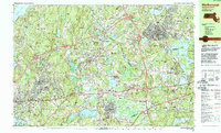
1983 Map of Marlborough
USGS Topo · Published 1990About this map
Marlborough serves as a major urban hub in this early 1980s landscape, where dense residential networks meet significant industrial and institutional land use. To the south, the expansive grounds of the Westborough State Hospital overlook Chauncy Lake, while the local aviation history of Marlborough Airport is visible on the eastern edge. The region’s transport evolution is evident in the heavy concentration of highway interchanges, such as Interchange 24, which contrast with the older rail lines of the Conrail system passing through Marlborough Junction.
Find a feature on this map
143 named features on this map. Tap any name to fly to it.
Don’t see what you’re looking for? This feature index may not catch every label — zoom into the map to look around manually.
Map Details
Editions of this 1983 Marlborough Map
3 editions found
Other maps of this area

1885 · Worcester
USGS Topo · 1:62,500

1886 · Worcester
USGS Topo · 1:62,500

1886 · Blackstone
USGS Topo · 1:62,500

1886 · Framingham
USGS Topo · 1:62,500

1887 · Franklin
USGS Topo · 1:62,500

1887 · Marlboro
USGS Topo · 1:62,500

1889 · Marlboro
USGS Topo · 1:62,500

1889 · Blackstone
USGS Topo · 1:62,500

1889 · Webster
USGS Topo · 1:62,500

1889 · Franklin
USGS Topo · 1:62,500