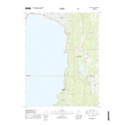
2018 Map of Marlette Lake
USGS Topo · Published 2018About this map
Lake Tahoe dominates the western half of this Nevada landscape, where the waters of Crystal Bay meet a coastline marked by recreational beaches and high-elevation reservoirs. Along the northern shore, Incline Beach and Sierra Nevada College indicate the development footprint near the Washoe Co and Carson City border. Further south, the map details the critical water infrastructure of the Carson Range, centered on Marlette Lake and the Marlette Dam. These features, along with Marlette Reservoir, illustrate the management of alpine water resources within the Toyabe National Forest.
Find a feature on this map
46 named features on this map. Tap any name to fly to it.
Don’t see what you’re looking for? This feature index may not catch every label — zoom into the map to look around manually.
Map Details
Editions of this 2018 Marlette Lake Map
This is the sole edition of this map. No revisions or reprints were ever made.
Other maps of this area

1891 · Carson
USGS Topo · 1:125,000

1891 · Truckee
USGS Topo · 1:125,000

1893 · Carson
USGS Topo · 1:125,000

1893 · Truckee
USGS Topo · 1:125,000

1895 · Truckee
USGS Topo · 1:125,000

1932 · Truckee
USGS Topo · 1:96,000

1940 · Truckee
USGS Topo · 1:125,000

1950 · Mt. Rose
USGS Topo · 1:62,500

1952 · Mt. Rose
USGS Topo · 1:62,500
1955 · Meeks Bay
USGS Topo · 1:24,000