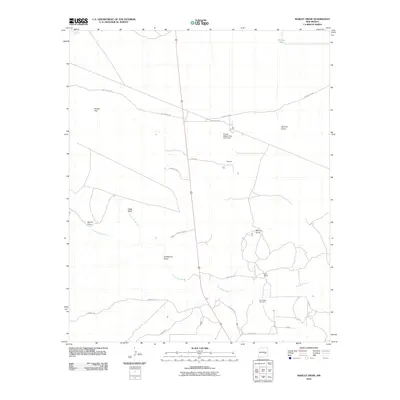
2010 Map of Marley Draw
USGS Topo · Published 2010About this map
Arroyo del Macho and its various tributaries define this section of the New Mexico landscape, carving through the terrain near landmarks like Chalk Bluff and Round Top. The 2010 survey illustrates a sparsely settled region of Chaves County where large ranching operations and utility infrastructure dominate the space. Local family and ranching history is anchored by Corn Ranch and the community of Brewton, while the industrial footprint of the era is evidenced by the El Paso Natural Gas Co Airport. Further south, the Eden Valley Cemetery serves as a significant genealogical landmark for the area. The map also detail a network of rural routes, including Bitterroot Rd and Red Bluff Rd, which connect the scattered draws such as Marley Draw and Hackberry Draw to the primary north-south highway.
Find a feature on this map
22 named features on this map. Tap any name to fly to it.
Don’t see what you’re looking for? This feature index may not catch every label — zoom into the map to look around manually.
Map Details
Editions of this 2010 Marley Draw Map
This is the sole edition of this map. No revisions or reprints were ever made.
Other maps of this area

1955 · Roswell
USGS Topo · 1:250,000

1958 · Roswell
USGS Topo · 1:250,000

1962 · Roswell
USGS Topo · 1:250,000

1962 · Rock House Canyon
USGS Topo · 1:24,000

1962 · Panther Hill
USGS Topo · 1:24,000
1962 · Melena
USGS Topo · 1:24,000

1962 · Marley Draw
USGS Topo · 1:24,000
1963 · Barn Draw
USGS Topo · 1:24,000

1963 · Coyote Draw
USGS Topo · 1:24,000
1967 · Mesa SE
USGS Topo · 1:24,000