
1963 Map of Coyote Draw
USGS Topo · Published 1964About this map
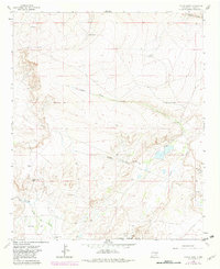
Coyote Draw and Fivemile Draw cut through this high desert portion of Chaves County, defining a landscape where water management was essential to ranching survival. The map illustrates a network of named water sources and livestock infrastructure including Red Bluff Well, Savage Well, and the Smith Windmill. To the south, the terrain descends toward the Bitter Lake National Wildlife Refuge, featuring distinctive alkali flats and depressions like Yellow Lake Sink and Cocklebur Lakes. This 1960s environment is characterized by the presence of Red Bluff Ranch and a significant pipeline corridor, showing the intersection of traditional land use and mid-century industrial development. Localized landmarks such as Garcia Flat and the meandering Arroyo del Macho provide specific points of interest for those tracing the historical geography of the Pecos River valley hinterlands.
Find a feature on this map
22 named features on this map. Tap any name to fly to it.
Don’t see what you’re looking for? This feature index may not catch every label — zoom into the map to look around manually.
Map Details
Editions of this 1963 Coyote Draw Map
2 editions found
Other maps of this area

1955 · Roswell
USGS Topo · 1:250,000

1958 · Roswell
USGS Topo · 1:250,000

1962 · Roswell
USGS Topo · 1:250,000

1962 · Eightmile Draw
USGS Topo · 1:24,000

1962 · Panther Hill
USGS Topo · 1:24,000

1962 · Acme
USGS Topo · 1:24,000
1962 · Melena
USGS Topo · 1:24,000

1962 · Marley Draw
USGS Topo · 1:24,000

1967 · Cottonwood Draw
USGS Topo · 1:24,000
1967 · Mesa SE
USGS Topo · 1:24,000