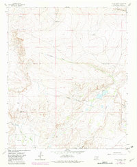
1963 Map of Coyote Draw
USGS Topo · Published 1982About this map
Bitter Lake National Wildlife Refuge anchors the southern portion of this Chaves County landscape, where the Chihuahuan Desert meets critical wetland basins. The topography is defined by ephemeral drainage systems like Coyote Draw and Milner Draw, which feed into a complex of seasonal water bodies including Cocklebur Lakes, Milner Lake, and Yellow Lake. These water sources were vital for early ranching operations, as evidenced by the dispersed network of improvements such as Savage Well, Dixon Well, and the Smith Windmill. Ranching history is further highlighted by the Red Bluff Ranch and Garcia Flat to the south. This 1963 survey, photorevised in 1982, captures the arid terrain's transition from open range to a managed wildlife corridor, with industrial infrastructure represented by the prominent Pipeline corridors cutting across the draws.
Find a feature on this map
24 named features on this map. Tap any name to fly to it.
Don’t see what you’re looking for? This feature index may not catch every label — zoom into the map to look around manually.
Map Details
Editions of this 1963 Coyote Draw Map
2 editions found
Other maps of this area

1955 · Roswell
USGS Topo · 1:250,000

1958 · Roswell
USGS Topo · 1:250,000

1962 · Roswell
USGS Topo · 1:250,000

1962 · Eightmile Draw
USGS Topo · 1:24,000

1962 · Panther Hill
USGS Topo · 1:24,000

1962 · Acme
USGS Topo · 1:24,000
1962 · Melena
USGS Topo · 1:24,000

1962 · Marley Draw
USGS Topo · 1:24,000

1963 · Coyote Draw
USGS Topo · 1:24,000

1967 · Cottonwood Draw
USGS Topo · 1:24,000