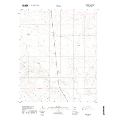
2020 Map of Marley Draw
USGS Topo · Published 2020About this map
Arroyo del Macho and its network of ephemeral watercourses carve through this section of the Pecos Valley upland, defining the drainage patterns of the high plains north of Roswell. The landscape is characterized by its broad, arid draws, including Marley Draw, Hackberry Draw, and Bajillo Draw, which represent the primary relief in an area primarily used for ranching and resource access. Modern infrastructure is dominated by the corridor of N Main St, while a network of rural routes like Red Bluff Rd and Co RD 39 provide access to the surrounding rangeland. In the eastern portion of the map, the Eden Valley area contains the isolated Eden Valley Cem, a key landmark for local genealogical research. Distinctive topographic features such as Round Top and Chalk Bluff rise above the plains, serving as traditional navigational points in a terrain otherwise defined by the wide, shallow depressions of Selman Draw.
Find a feature on this map
30 named features on this map. Tap any name to fly to it.
Don’t see what you’re looking for? This feature index may not catch every label — zoom into the map to look around manually.
Map Details
Editions of this 2020 Marley Draw Map
This is the sole edition of this map. No revisions or reprints were ever made.
Other maps of this area

1955 · Roswell
USGS Topo · 1:250,000

1958 · Roswell
USGS Topo · 1:250,000

1962 · Roswell
USGS Topo · 1:250,000

1962 · Rock House Canyon
USGS Topo · 1:24,000

1962 · Panther Hill
USGS Topo · 1:24,000
1962 · Melena
USGS Topo · 1:24,000

1962 · Marley Draw
USGS Topo · 1:24,000
1963 · Barn Draw
USGS Topo · 1:24,000

1963 · Coyote Draw
USGS Topo · 1:24,000
1967 · Mesa SE
USGS Topo · 1:24,000