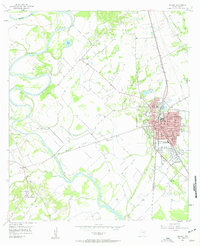
1957 Map of Marlin
USGS Topo · Published 1958About this map
The Brazos River meanders through the heart of the central Texas landscape, shaping a complex network of wetlands including Barganier Slough and McCullough Slough. At the center of this 1950s survey, the city of Marlin serves as a vital rail and civic hub, anchored by the Courthouse and the expansive U S Veterans Hospital. The town's infrastructure is defined by the crossing of the Missouri Pacific and Texas and New Orleans railroads, which supported local industry like the Oil Mill. Outside the city limits, the rural character is preserved through small settlements like Rocky Hill and Triangle. For genealogists, the map is a detailed resource for locating community landmarks such as the Booker T Washington High Sch, Elm Grove Ch, and Stallworth Cem, many of which represent long-standing family and congregational centers in Falls County.
Find a feature on this map
33 named features on this map. Tap any name to fly to it.
Don’t see what you’re looking for? This feature index may not catch every label — zoom into the map to look around manually.
Map Details
Editions of this 1957 Marlin Map
3 editions found
Other maps of this area

1892 · Temple
USGS Topo · 1:125,000

1954 · Waco
USGS Topo · 1:250,000

1955 · Waco
USGS Topo · 1:250,000

1957 · Otto
USGS Topo · 1:24,000

1957 · McClanahan
USGS Topo · 1:24,000

1957 · Riesel
USGS Topo · 1:24,000

1957 · Chilton
USGS Topo · 1:24,000

1957 · Marlin
USGS Topo · 1:24,000
1957 · Robinson
USGS Topo · 1:24,000

1962 · Reagan
USGS Topo · 1:24,000