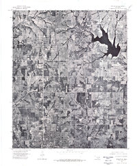
1975 Map of Marlow SW
USGS Topo · Published 1976About this map
The northern reaches of Duncan dominate the southern portion of this 1975 aerial orthophotoquad, showing the city's residential and industrial footprint before late-century expansion. The landscape transitions from urban grid patterns into a series of agricultural plots and pastureland defined by the winding course of Wildhorse Creek. This rare visual record captures the precise state of the land surface at a time when the Lake Humphreys reservoir was well-established as a primary feature of the local topography. By using direct photoimagery rather than traditional topographic lines, the map reveals the specific textures of the Oklahoma plains, including tree lines, field boundaries, and the evolving infrastructure around the city limits.
Find a feature on this map
3 named features on this map. Tap any name to fly to it.
Don’t see what you’re looking for? This feature index may not catch every label — zoom into the map to look around manually.
Map Details
Editions of this 1975 Marlow SW Map
This is the sole edition of this map. No revisions or reprints were ever made.
Other maps of this area

1901 · Addington
USGS Topo · 1:125,000

1902 · Rush Springs
USGS Topo · 1:125,000

1949 · Nellie
USGS Topo · 1:62,500

1950 · Marlow
USGS Topo · 1:62,500

1951 · Marlow
USGS Topo · 1:62,500

1955 · Lawton
USGS Topo · 1:250,000
1956 · Denton
USGS Topo · 1:24,000

1956 · Nellie
USGS Topo · 1:24,000

1956 · Nellie
USGS Topo · 1:62,500

1957 · Ardmore
USGS Topo · 1:250,000