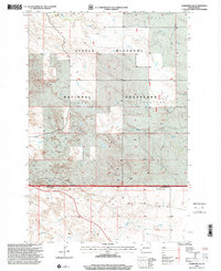
1997 Map of Marmarth SE
USGS Topo · Published 2001About this map
Fort Dilts State Historic Site marks a significant historical point on this landscape near the border of Slope and Bowman counties. Established during the 1860s as a defensive position for a wagon train under siege, the site is preserved within the expansive Little Missouri National Grassland. The terrain is defined by a network of drainage systems including Indian Creek, Bacon Creek, and Hay Creek, which carve through the high plains toward the Mound landmark in the north. The survey also identifies the Hughes Crawford area, illustrating a region shaped by both public land management and the rugged cattle-ranching geography of the North Dakota badlands. This late-twentieth-century revision provides a clear view of the sparse infrastructure, showing localized landmarks like Dickey Draw, Worser Creek, and a highway Rest Area.
Find a feature on this map
11 named features on this map. Tap any name to fly to it.
Don’t see what you’re looking for? This feature index may not catch every label — zoom into the map to look around manually.
Map Details
Editions of this 1997 Marmarth SE Map
This is the sole edition of this map. No revisions or reprints were ever made.
Other maps of this area

1953 · Dickinson
USGS Topo · 1:250,000

1957 · Dickinson
USGS Topo · 1:250,000

1973 · Kid Creek
USGS Topo · 1:24,000

1973 · Cedar Hills
USGS Topo · 1:24,000

1973 · Rhame
USGS Topo · 1:24,000

1979 · Ives
USGS Topo · 1:24,000

1980 · Pretty Butte
USGS Topo · 1:24,000

1980 · Marmarth
USGS Topo · 1:24,000

1980 · Boyce Creek West
USGS Topo · 1:24,000

1981 · Bowman
USGS Topo · 1:100,000