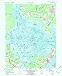
1952 Map of Marmora
USGS Topo · Published 1984About this map
Great Egg Harbor River serves as the central artery of this coastal landscape, where the tides of Great Egg Harbor Bay meet a complex network of marshes and winding creeks. The map documents a period of significant transition in southern New Jersey as the traditional river-based economy, evidenced by English Creek Landing and Scull Landing, began to shift toward automobile-driven expansion. The introduction of the Garden State Parkway cuts through the eastern half of the sheet, signaling the era of modern connectivity that would soon redefine these historic communities.
Find a feature on this map
79 named features on this map. Tap any name to fly to it.
Don’t see what you’re looking for? This feature index may not catch every label — zoom into the map to look around manually.
Map Details
Editions of this 1952 Marmora Map
4 editions found
Other maps of this area

1884 · Sea Isle
USGS Topo · 1:62,500

1888 · Dennisville
USGS Topo · 1:62,500

1888 · Sea Isle
USGS Topo · 1:62,500

1890 · Great Egg Harbor
USGS Topo · 1:62,500

1890 · Tuckahoe
USGS Topo · 1:62,500

1893 · Great Egg Harbor
USGS Topo · 1:62,500

1893 · Tuckahoe
USGS Topo · 1:62,500

1894 · Dennisville
USGS Topo · 1:62,500

1894 · Sea Isle
USGS Topo · 1:62,500

1918 · Great Egg Harbor
USGS Topo · 1:62,500