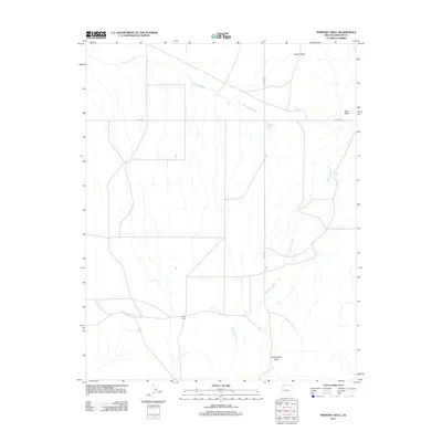
2011 Map of Maroney Well
USGS Topo · Published 2011About this map
Yellowstone Mesa anchors the southern reaches of this Mohave County landscape, where the drainage patterns of Big Sand Wash and Sandridge Wash define the terrain. These ephemeral waterways converge near the namesake Maroney Well, a vital water point in an arid region characterized by extensive valleys and elevated ridges. The map illustrates a sparse network of ranching and transit infrastructure, including Esplins Corral and the intersection of Co HWY 239 and Co HWY 241. From the high point at Cedar Ridge to the low expanse of Pipe Valley, the 2011 survey documents the persistent reliance on localized water features like Fern Tank to support life and movement across the Arizona strip.
Find a feature on this map
10 named features on this map. Tap any name to fly to it.
Don’t see what you’re looking for? This feature index may not catch every label — zoom into the map to look around manually.
Map Details
Editions of this 2011 Maroney Well Map
This is the sole edition of this map. No revisions or reprints were ever made.
Other maps of this area

1886 · Mt. Trumbull
USGS Topo · 1:250,000

1886 · Kaibab
USGS Topo · 1:250,000

1892 · Mt. Trumbull
USGS Topo · 1:250,000

1953 · Grand Canyon
USGS Topo · 1:250,000

1954 · Heaton Knolls NW
USGS Topo · 1:24,000

1954 · Lost Spring SE
USGS Topo · 1:24,000
1954 · Short Creek SW
USGS Topo · 1:24,000

1954 · Short Creek SE
USGS Topo · 1:24,000
1954 · Short Creek NW
USGS Topo · 1:24,000
1954 · Lost Spring Mtn
USGS Topo · 1:62,500