
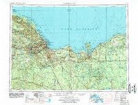
1958 Map of Marquette
USGS Topo · Published 1968About this map
Marquette and the neighboring mining centers of Ishpeming and Negaunee anchor the northern shore of the Upper Peninsula in this late-1950s survey. The landscape is defined by vast public lands and industrial infrastructure, ranging from the Hiawatha National Forest to the specialized Lake Superior and Ishpeming Railroad. Coastal landmarks like Grand Island, Miners Castle, and the Big Bay Point Lighthouse highlight the maritime importance of the Lake Superior shoreline. Inland, the map reveals a network of small timber and rail settlements such as Eben Junction, Trenary, and Republic. The transition from heavy extraction to postwar defense is visible at the K.I. Sawyer Air Force Base, while conservation efforts are marked by the sprawling Seney National Wildlife Refuge. Numerous state forests, including Escanaba River State Forest, dominate the interior, tracing the paths of the Sturgeon River and Manistique River.
Find a feature on this map
258 named features on this map. Tap any name to fly to it.
Don’t see what you’re looking for? This feature index may not catch every label — zoom into the map to look around manually.
Map Details
Editions of this 1958 Marquette Map
2 editions found
Other maps of this area

1899 · Sagola
USGS Topo · 1:62,500

1899 · Witbeck
USGS Topo · 1:62,500

1907 · Marquette
USGS Topo · 1:62,500

1931 · Cooks NE
USGS Topo · 1:31,680

1931 · Seney SW
USGS Topo · 1:31,680

1931 · Seney NW
USGS Topo · 1:31,680

1931 · Steuben SE
USGS Topo · 1:31,680

1931 · Manistique River NE
USGS Topo · 1:31,680

1931 · Steuben SW
USGS Topo · 1:31,680

1931 · Driggs Lake NE
USGS Topo · 1:31,680