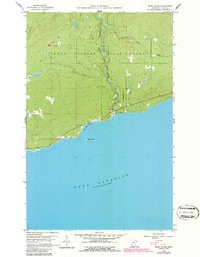
1960 Map of Marr Island
USGS Topo · Published 1986About this map
Judge C.R. Magney State Park and the Grand Portage State Forest dominate this stretch of the North Shore, where the Brule River cuts through the timbered uplands toward Lake Superior. The 1960 field data, updated in the mid-1980s, reveals a coastline defined by recreation and small-scale land use, featuring the Campground and Arrowhead Park near the river's mouth. Further west along the shore, Paradise Beach sits protected by the small landmass of Marr Island. Inland, the map documents a sparse network of roads and natural drainages like Gauthier Creek and Murphy Creek, alongside more practical markings of the era such as a Gravel Pit and a lone Cem (cemetery). This survey provides a clear look at the landscape before modern development further altered the entry points to the state parks and forest lands.
Find a feature on this map
16 named features on this map. Tap any name to fly to it.
Don’t see what you’re looking for? This feature index may not catch every label — zoom into the map to look around manually.
Map Details
Editions of this 1960 Marr Island Map
4 editions found
Other maps of this area

1954 · Two Harbors
USGS Topo · 1:250,000

1957 · Two Harbors
USGS Topo · 1:250,000

1958 · Two Harbors
USGS Topo · 1:250,000

1958 · Hancock
USGS Topo · 1:250,000

1959 · Northern Light Lake
USGS Topo · 1:24,000

1959 · Tom Lake
USGS Topo · 1:24,000

1960 · Hancock
USGS Topo · 1:250,000
1960 · Farquhar Peak
USGS Topo · 1:24,000
1960 · Hovland
USGS Topo · 1:24,000
1960 · Kadunce Creek
USGS Topo · 1:24,000