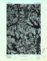
1975 Map of Mars Hill NW
USGS Topo · Published 1981About this map
The United States Canada international border defines the eastern edge of this 1975 orthophotograph, where the agricultural landscape of Aroostook County meets Maine New Brunswick. This aerial perspective captures the rural character of the region during the mid-1970s, revealing a dense patchwork of cleared fields and woodlots. The settlement of Easton serves as a central hub, while the rail-oriented site of Easton Station sits to the north, illustrating the historical importance of the railway in transporting the area's agricultural products. Prestile Stream winds through the southern portion of the quadrangle, passing near the small community of Phair. In the northern section, the cluster at Parkhurst further demonstrates the dispersed settlement pattern typical of this borderland farming country.
Find a feature on this map
8 named features on this map. Tap any name to fly to it.
Don’t see what you’re looking for? This feature index may not catch every label — zoom into the map to look around manually.
Map Details
Editions of this 1975 Mars Hill NW Map
2 editions found
Other maps of this area

1929 · Caribou
USGS Topo · 1:48,000

1930 · Fort Fairfield
USGS Topo · 1:48,000

1932 · Caribou
USGS Topo · 1:62,500

1933 · Fort Fairfield
USGS Topo · 1:62,500

1935 · Presque Isle
USGS Topo · 1:62,500

1936 · Mars Hill
USGS Topo · 1:48,000

1940 · Mars Hill
USGS Topo · 1:62,500

1951 · Mars Hill
USGS Topo · 1:62,500

1951 · Fort Fairfield
USGS Topo · 1:62,500

1953 · Presque Isle
USGS Topo · 1:62,500