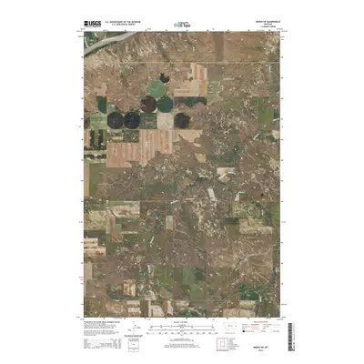
2014 Map of Marsh SW
USGS Topo · Published 2014About this map
The Yellowstone River cuts through the northwest corner of this landscape, defining a rugged boundary in a region of high plains and dissected plateaus. Steep escarpments like Barrs Bluffs overlook the river valley, while the expansive Fallon Flat represents the characteristic level benchlands of eastern Montana. The map documents the rural infrastructure of Prairie Co and Dawson Co, where historic access points like Dewalt School Rd and Marsh Rd trace the path of early homesteading and ranching efforts. A network of seasonal drainages, including Bad Route Cr, Spring Cr, and Ash Cr, carves the terrain into a complex system of ridges and coulees. These watercourses and their associated roads, such as Spring Creek Rd and Cabin Creek Rd, highlight how the natural topography dictated the development of local transport and land use.
Find a feature on this map
17 named features on this map. Tap any name to fly to it.
Don’t see what you’re looking for? This feature index may not catch every label — zoom into the map to look around manually.
Map Details
Editions of this 2014 Marsh SW Map
This is the sole edition of this map. No revisions or reprints were ever made.
Other maps of this area

1953 · Miles City
USGS Topo · 1:250,000

1957 · Miles City
USGS Topo · 1:250,000

1958 · Miles City
USGS Topo · 1:250,000

1966 · Fallon
USGS Topo · 1:24,000

1966 · Marsh SW
USGS Topo · 1:24,000

1967 · Marsh
USGS Topo · 1:24,000

1967 · Hoyt
USGS Topo · 1:24,000
1967 · Fallon NE
USGS Topo · 1:24,000

1969 · Flat Top Butte NE
USGS Topo · 1:24,000

1980 · Terry
USGS Topo · 1:100,000