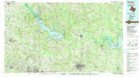
1986 Map of Marshall
USGS Topo · Published 1986About this map
Lake O' the Pines and the extensive marshlands of Caddo Lake dominate this East Texas landscape, reflecting a region defined by its water resources and industrial development in the mid-1980s. The map illustrates a complex network of energy and military infrastructure, most notably the Rodessa Oil Field and the sprawling Longhorn Army Ammunition Plant near the Louisiana border. These industrial sites are juxtaposed with numerous named peaks such as White Oak Mountain and Howell Mountain, which rise above the river bottoms of Big Cypress Bayou and the Sabine River.
Find a feature on this map
171 named features on this map. Tap any name to fly to it.
Don’t see what you’re looking for? This feature index may not catch every label — zoom into the map to look around manually.
Map Details
Editions of this 1986 Marshall Map
2 editions found
Other maps of this area

1907 · Atlanta
USGS Topo · 1:62,500

1910 · Linden
USGS Topo · 1:62,500

1910 · Atlanta
USGS Topo · 1:62,500

1914 · Daingerfield
USGS Topo · 1:62,500

1932 · Hosston NW
USGS Topo · 1:31,680

1932 · Hosston SW
USGS Topo · 1:31,680

1936 · Kilgore
USGS Topo · 1:48,000

1938 · Winona
USGS Topo · 1:48,000

1940 · Kilgore
USGS Topo · 1:62,500

1943 · Winona
USGS Topo · 1:62,500