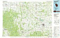
1984 Map of Marshfield
USGS Topo · Published 1985About this map
Marshfield serves as the primary hub for this mid-1980s landscape, which spans the intersection of Clark, Marathon, and Wood Counties. The region is defined by a dense network of dairy country townships and the critical transport lines of the Soo Line, Chicago and North Western, and Wisconsin Central railroads. These rail corridors link rural dairy-support settlements like Abbotsford, Loyal, and Greenwood. To the west, the terrain transitions into the dense forest and marshland of the Blue Swamp and the Iron River Flowage, while the eastern portion highlights the developed McMillan State Wildlife Area. Cultural landmarks such as the University of Wisconsin (Marshfield-Wood Co Campus) and recreational sites like Mead Lake and Powers Bluff County Park reflect the region's balance of agricultural industry and public land management during this era.
Find a feature on this map
117 named features on this map. Tap any name to fly to it.
Don’t see what you’re looking for? This feature index may not catch every label — zoom into the map to look around manually.
Map Details
Editions of this 1984 Marshfield Map
2 editions found
Other maps of this area

1902 · Marathon
USGS Topo · 1:125,000

1924 · Black River Falls
USGS Topo · 1:62,500

1926 · Black River Falls
USGS Topo · 1:62,500

1927 · Blair
USGS Topo · 1:62,500

1935 · Osseo
USGS Topo · 1:48,000

1940 · Osseo
USGS Topo · 1:62,500

1948 · Fairchild
USGS Topo · 1:62,500

1949 · Fairchild
USGS Topo · 1:62,500

1951 · Cornell
USGS Topo · 1:62,500

1951 · Lublin
USGS Topo · 1:48,000