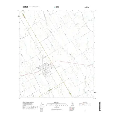
2019 Map of Mart
USGS Topo · Published 2019About this map
Mart sits at the intersection of several county lines in this central Texas landscape, where the borders of McLennan, Limestone, and Falls counties converge. The street grid of the town is detailed alongside local landmarks such as Evergreen Cem and Wise Cem. The surrounding countryside is defined by an intricate network of waterways, including the winding Cottonwood Cr, Big Cr, and Hogpen Cr, which dictate the rural road patterns and property divisions of the region. To the northeast, the settlement of Victoria appears near Christmas Cr, illustrating the dispersed nature of local communities. The map highlights the transition from the organized urban center of Mart to the sprawling agricultural tracts characterized by numerous creeks like Indian Camp Cr and Barger Br. Researchers can trace the path of FM 939 and various county roads as they connect these scattered homesteads and burial grounds.
Find a feature on this map
94 named features on this map. Tap any name to fly to it.
Don’t see what you’re looking for? This feature index may not catch every label — zoom into the map to look around manually.
Map Details
Editions of this 2019 Mart Map
This is the sole edition of this map. No revisions or reprints were ever made.
Other maps of this area

1920 · Mart
USGS Topo · 1:62,500

1954 · Waco
USGS Topo · 1:250,000

1955 · Waco
USGS Topo · 1:250,000

1956 · Axtell
USGS Topo · 1:24,000

1956 · Mart
USGS Topo · 1:24,000

1957 · Prairie Hill
USGS Topo · 1:24,000

1957 · Groesbeck
USGS Topo · 1:62,500

1957 · Otto
USGS Topo · 1:24,000

1957 · Riesel
USGS Topo · 1:24,000
1957 · Elk
USGS Topo · 1:24,000