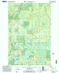
1999 Map of Marten Lake
USGS Topo · Published 2004About this map
Ottawa National Forest dominates this landscape on the borders of Houghton, Baraga, and Iron Counties. The terrain is defined by a high density of glacial lakes and wetlands, connected by small waterways like Smith Creek and Erickson Creek. Larger water bodies such as Marten Lake, Norway Lake, and the distinctly named Lake Thirteen provide the primary geographic landmarks. The presence of several Gravel Pits and a Sandpit suggests localized resource extraction typical of the region's industrial history.
Find a feature on this map
29 named features on this map. Tap any name to fly to it.
Don’t see what you’re looking for? This feature index may not catch every label — zoom into the map to look around manually.
Map Details
Editions of this 1999 Marten Lake Map
This is the sole edition of this map. No revisions or reprints were ever made.
Other maps of this area

1895 · Perch Lake
USGS Topo · 1:62,500

1954 · Rousseau
USGS Topo · 1:62,500

1954 · Kenton
USGS Topo · 1:62,500

1954 · Perch Lake
USGS Topo · 1:62,500

1954 · Sidnaw
USGS Topo · 1:62,500

1958 · Iron River
USGS Topo · 1:250,000

1960 · Iron River
USGS Topo · 1:250,000

1961 · Iron River
USGS Topo · 1:250,000

1967 · Iron River
USGS Topo · 1:250,000
1982 · Echo Lake
USGS Topo · 1:25,000