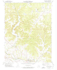
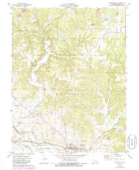
1972 Map of Marthasville
USGS Topo · Published 1975About this map
Marthasville and the surrounding river bottoms define this section of Warren County, where the Missouri - Kansas - Texas railroad corridor parallels the Missouri River. The landscape is shaped by the winding course of Charrette Creek and its tributaries, such as the North Fork, which cut through the uplands before reaching the fertile La Charrette Bottom. Small settlements like Peers and Martha are situated along the lower elevations, while the higher ground is dotted with active industrial sites, including several Quarries and claypits in the Hickory Grove and Charrette townships.
Find a feature on this map
31 named features on this map. Tap any name to fly to it.
Don’t see what you’re looking for? This feature index may not catch every label — zoom into the map to look around manually.
Map Details
Editions of this 1972 Marthasville Map
2 editions found
Other maps of this area

1890 · Hermann
USGS Topo · 1:125,000

1903 · O'Fallon
USGS Topo · 1:125,000

1941 · Troy
USGS Topo · 1:62,500

1943 · Warrenton
USGS Topo · 1:62,500

1945 · Troy
USGS Topo · 1:62,500

1945 · Warrenton
USGS Topo · 1:62,500
1948 · Washington
USGS Topo · 1:62,500

1948 · Augusta
USGS Topo · 1:62,500

1949 · Saint Louis
USGS Topo · 1:250,000
1949 · Washington
USGS Topo · 1:62,500