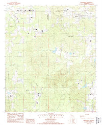
1988 Map of Marthaville
USGS Topo · Published 1988About this map
Marthaville and its surrounding countryside define this 1980s landscape along the border of Natchitoches and Sabine Parishes. The area is marked by a network of waterways including Brushy Creek and Whitlock Creek that feed into larger bayous like Bayou Dupont. Small settlements such as Thomas, Klondike, and Vista appear as distinct clusters of development within a predominantly rural and wooded environment.
Find a feature on this map
25 named features on this map. Tap any name to fly to it.
Don’t see what you’re looking for? This feature index may not catch every label — zoom into the map to look around manually.
Map Details
Editions of this 1988 Marthaville Map
This is the sole edition of this map. No revisions or reprints were ever made.
Other maps of this area

1938 · Hollis Creek
USGS Topo · 1:31,680

1938 · Allen
USGS Topo · 1:31,680

1941 · Zwolle
USGS Topo · 1:62,500

1941 · Pelican
USGS Topo · 1:62,500

1942 · Many
USGS Topo · 1:62,500

1943 · Many
USGS Topo · 1:62,500

1943 · Pleasant Hill
USGS Topo · 1:62,500

1944 · Zwolle
USGS Topo · 1:62,500

1944 · Pleasant Hill
USGS Topo · 1:62,500

1947 · Hanna
USGS Topo · 1:62,500