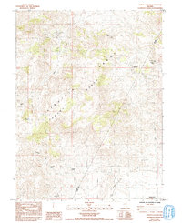
1985 Map of Martin Canyon
USGS Topo · Published 1993About this map
Mining operations and high-desert springs define the landscape where the Virginia Range meets the Flowery Range. This map documents the remote industrial activity of the mid-1970s and 1980s, centered on several significant extractive sites including the Gooseberry Mine and the Ramsey Comstock Mine. The historic footprint of mining in this region of Storey and Lyon counties is evidenced by Ramsey (Site), a former settlement located on the eastern slopes of the range near San Juan Hill.
Find a feature on this map
17 named features on this map. Tap any name to fly to it.
Don’t see what you’re looking for? This feature index may not catch every label — zoom into the map to look around manually.
Map Details
Editions of this 1985 Martin Canyon Map
2 editions found
Other maps of this area

1890 · Wadsworth
USGS Topo · 1:125,000

1891 · Carson
USGS Topo · 1:125,000

1891 · Wabuska
USGS Topo · 1:125,000

1891 · Reno
USGS Topo · 1:125,000

1892 · Wadsworth
USGS Topo · 1:125,000

1893 · Carson
USGS Topo · 1:125,000

1893 · Reno
USGS Topo · 1:125,000

1894 · Wadsworth
USGS Topo · 1:125,000

1894 · Wabuska
USGS Topo · 1:125,000

1950 · Virginia City
USGS Topo · 1:62,500