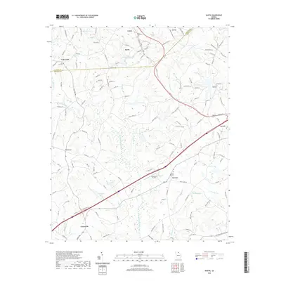
2020 Map of Martin
USGS Topo · Published 2020About this map
Martin and Avalon sit along the boundary between Stephens and Franklin counties, serving as central hubs in a landscape defined by a complex network of reservoirs and watercourses. The North Fork Broad River and its various tributaries, such as Toms Cr and Clarks Cr, feed into numerous numbered reservoirs like Reservoir 32 and Reservoir Five, which characterize the modern hydraulic management of the region. This 2020 survey reveals the proximity of Lavonia to the northeast and Carnesville to the southwest, connected by a dense lattice of local roads like Anderson Thomas Rd and Clarks Creek Rd. Family-named landmarks and historical community anchors remain prominent, from the Martin Community Cem to the Pleasant Hill Cem. The presence of the Broad River Air Park near Fairview illustrates the integration of aviation infrastructure within this traditionally agricultural and creek-cut terrain of northeast Georgia.
Find a feature on this map
137 named features on this map. Tap any name to fly to it.
Don’t see what you’re looking for? This feature index may not catch every label — zoom into the map to look around manually.
Map Details
Editions of this 2020 Martin Map
This is the sole edition of this map. No revisions or reprints were ever made.
Other maps of this area

1886 · Walhalla
USGS Topo · 1:125,000

1891 · Carnesville
USGS Topo · 1:125,000

1892 · Walhalla
USGS Topo · 1:125,000

1896 · Walhalla
USGS Topo · 1:125,000

1954 · Greenville
USGS Topo · 1:250,000

1958 · Greenville
USGS Topo · 1:250,000

1959 · Carnesville
USGS Topo · 1:24,000

1959 · Lavonia
USGS Topo · 1:24,000

1959 · Royston
USGS Topo · 1:24,000

1960 · Martin
USGS Topo · 1:24,000