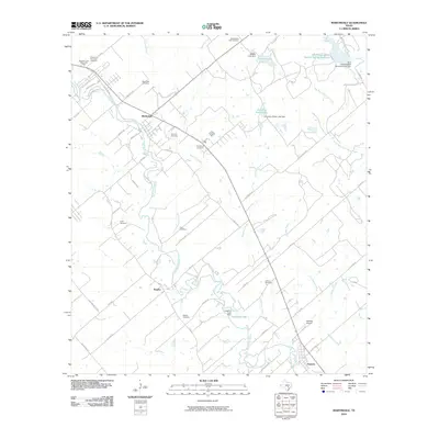
2010 Map of Martindale
USGS Topo · Published 2010About this map
The San Marcos River anchors the landscape of this Central Texas corridor, winding southward from Martindale through Staples toward Fentress. The map illustrates a rural landscape defined by historic family-named burial grounds and water management infrastructure, including the Soil Conservation Service Site 34 Dam and Langford Lake Dam. These structures along tributaries like Hemphill Creek and Dickerson Creek reflect the region's long-standing efforts to manage the river's flood-prone basin.
Find a feature on this map
60 named features on this map. Tap any name to fly to it.
Don’t see what you’re looking for? This feature index may not catch every label — zoom into the map to look around manually.
Map Details
Editions of this 2010 Martindale Map
This is the sole edition of this map. No revisions or reprints were ever made.
Other maps of this area

1911 · San Marcos
USGS Topo · 1:125,000

1919 · San Marcos
USGS Topo · 1:125,000

1929 · Luling
USGS Topo · 1:62,500

1930 · Lockhart
USGS Topo · 1:62,500

1930 · Seguin
USGS Topo · 1:62,500

1953 · Seguin
USGS Topo · 1:250,000

1958 · Seguin
USGS Topo · 1:250,000

1963 · Lockhart North
USGS Topo · 1:24,000
1964 · Kingsbury
USGS Topo · 1:24,000
1964 · Martindale
USGS Topo · 1:24,000