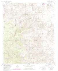
1981 Map of Martinez Mtn
USGS Topo · Published 1988About this map
The Santa Rosa Mountains dominate this 1980s landscape, with Martinez Mountain and Sheep Mountain rising as prominent peaks within the Santa Rosa Wilderness. The rugged terrain is defined by a network of deep drainages such as Martinez Canyon, Toro Canyon, and Agua Alta Canyon. Along the desert floor to the northeast, the Coachella Valley Aqueduct and Lake Cahuilla County Park mark the edge of the Coachella Valley development. This period captures the region as a largely preserved wilderness under the San Bernardino National Forest and State Game Refuge designations. Sparse water sources like Cactus Spring, Martinez Spring, and Aqua Alta Spring provide vital points of interest for historical land use and early navigation through the arid peaks.
Find a feature on this map
33 named features on this map. Tap any name to fly to it.
Don’t see what you’re looking for? This feature index may not catch every label — zoom into the map to look around manually.
Map Details
Editions of this 1981 Martinez Mtn Map
2 editions found
Other maps of this area

1904 · Indio
USGS Topo · 1:125,000

1931 · Vallecito
USGS Topo · 1:125,000

1941 · Toro Peak
USGS Topo · 1:62,500

1941 · Clark Lake
USGS Topo · 1:62,500

1941 · Coachella
USGS Topo · 1:62,500

1942 · Agua Dulce
USGS Topo · 1:62,500

1942 · Clark Lake
USGS Topo · 1:62,500

1943 · Vallecito
USGS Topo · 1:125,000

1943 · Coachella
USGS Topo · 1:62,500

1944 · Agua Dulce
USGS Topo · 1:62,500