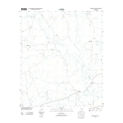
2013 Map of Martinsville
USGS Topo · Published 2013About this map
Martinsville anchors the southeastern corner of this Nacogdoches County landscape, situated along a network of country roads near the winding Attoyac River. The terrain is defined by a dense web of creek systems, including the long course of Naconiche Cr and the waters of Terrapin Cr. Smaller settlements such as Cedar Point and Waterman are connected by rural routes like FM-1878 and FM-95, reflecting a community structure tied to the local topography and waterways. Near the settlement of Grigsby, the presence of Grisby Lake and numerous marshy lowlands along the river plain suggests a geography dominated by seasonal drainage and riparian corridors. This 2013 survey provides a detailed look at the rural road network, from established Farm to Market roads to local tracks like Mt Moriah Rd and JB Nix Rd, illustrating how these routes navigate the numerous tributaries such as Waffelow Cr and Kingham Cr.
Find a feature on this map
53 named features on this map. Tap any name to fly to it.
Don’t see what you’re looking for? This feature index may not catch every label — zoom into the map to look around manually.
Map Details
Editions of this 2013 Martinsville Map
This is the sole edition of this map. No revisions or reprints were ever made.
Other maps of this area

1952 · Nacogdoches
USGS Topo · 1:62,500

1953 · Palestine
USGS Topo · 1:250,000

1957 · Palestine
USGS Topo · 1:250,000

1958 · Martinsville
USGS Topo · 1:62,500

1958 · Timpson
USGS Topo · 1:62,500

1960 · Mount Enterprise
USGS Topo · 1:62,500
1983 · Woden
USGS Topo · 1:24,000
1983 · Appleby
USGS Topo · 1:24,000

1984 · Palestine
USGS Topo · 1:250,000
1984 · Chireno North
USGS Topo · 1:24,000