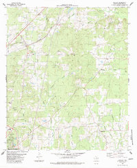
1983 Map of Appleby
USGS Topo · Published 1983About this map
The town of Appleby sits along the Southern Pacific railroad line in the early 1980s, serving as a focal point for this Nacogdoches County landscape. The topography is defined by an intricate network of waterways, including La Nana Bayou and Carrizo Bayou, which cut through the undulating terrain. Rural life is anchored by community landmarks such as High Morning Ch, Shady Grove Ch, and the High Sch located on the northern outskirts of Nacogdoches. Genealogists will find significant value in the documentation of local burial grounds like Bethel Cem, Post Oak Cem, and Moss Cem. The transition from the established rail corridor in the west to the more dispersed settlements of Pisgah and Shady Grove in the east illustrates a classic East Texas settlement pattern, where small communities grew around water sources like Atascoso Creek and Waffelow Creek.
Find a feature on this map
29 named features on this map. Tap any name to fly to it.
Don’t see what you’re looking for? This feature index may not catch every label — zoom into the map to look around manually.
Map Details
Editions of this 1983 Appleby Map
This is the sole edition of this map. No revisions or reprints were ever made.
Other maps of this area

1952 · Nacogdoches
USGS Topo · 1:62,500

1953 · Palestine
USGS Topo · 1:250,000

1957 · Palestine
USGS Topo · 1:250,000

1958 · Martinsville
USGS Topo · 1:62,500

1958 · Timpson
USGS Topo · 1:62,500

1960 · Mount Enterprise
USGS Topo · 1:62,500
1983 · Nacogdoches South
USGS Topo · 1:24,000
1983 · Woden
USGS Topo · 1:24,000
1983 · Nacogdoches North
USGS Topo · 1:24,000

1984 · Palestine
USGS Topo · 1:250,000