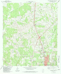
1983 Map of Nacogdoches North
USGS Topo · Published 1983About this map
Nacogdoches serves as the focal point of this East Texas survey, showing the city's northward growth into the surrounding timberlands and bayou country. The campus of Stephen F Austin State University occupies a significant portion of the southeastern landscape, flanked by established residential and civic features like Raguet Sch and a local Hosp. The Southern Pacific railroad line cuts through the terrain, connecting smaller outlying settlements such as Mahl, Central Heights, and Bonita Junction.
Find a feature on this map
45 named features on this map. Tap any name to fly to it.
Don’t see what you’re looking for? This feature index may not catch every label — zoom into the map to look around manually.
Map Details
Editions of this 1983 Nacogdoches North Map
This is the sole edition of this map. No revisions or reprints were ever made.
Other maps of this area

1943 · Cushing
USGS Topo · 1:62,500

1945 · Cushing
USGS Topo · 1:62,500

1952 · Douglass
USGS Topo · 1:62,500

1952 · Nacogdoches
USGS Topo · 1:62,500

1953 · Palestine
USGS Topo · 1:250,000

1957 · Palestine
USGS Topo · 1:250,000

1960 · Mount Enterprise
USGS Topo · 1:62,500

1973 · Cushing
USGS Topo · 1:24,000
1983 · Nacogdoches South
USGS Topo · 1:24,000
1983 · Lake Nacogdoches North
USGS Topo · 1:24,000