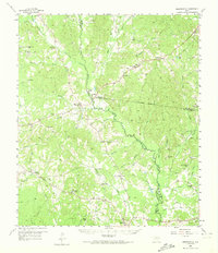
1958 Map of Martinsville
USGS Topo · Published 1974About this map
The historic El Camino Real cuts through the southwestern corner of this East Texas landscape, providing a tangible link to the region's colonial transit history. Centered on the boundary of Nacogdoches, Shelby, and San Augustine counties, the area is defined by the winding course of Attoyac Bayou and its numerous tributaries like Amaladeros Creek and Naconiche Creek. Small, dispersed agricultural settlements and community hubs such as Martinsville, Swift, and Melrose are anchored by local institutions, including Chireno Sch and Mt Herman Ch.
Find a feature on this map
60 named features on this map. Tap any name to fly to it.
Don’t see what you’re looking for? This feature index may not catch every label — zoom into the map to look around manually.
Map Details
Editions of this 1958 Martinsville Map
2 editions found
Other maps of this area

1949 · Lufkin
USGS Topo · 1:62,500

1949 · Platt
USGS Topo · 1:24,000

1950 · Platt
USGS Topo · 1:24,000

1952 · Nacogdoches
USGS Topo · 1:62,500

1953 · Palestine
USGS Topo · 1:250,000

1957 · Palestine
USGS Topo · 1:250,000

1958 · Center
USGS Topo · 1:62,500

1958 · Broaddus
USGS Topo · 1:62,500

1958 · San Augustine
USGS Topo · 1:62,500

1958 · Martinsville
USGS Topo · 1:62,500