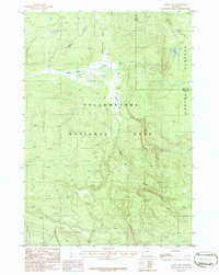
1986 Map of Mary Lake
USGS Topo · Published 1986About this map
Yellowstone National Park terrain is defined by the high elevations of the Central Plateau and the prominent heights of Mary Mountain. In the mid-1980s, this area remained largely undeveloped, with movement through the landscape dictated by a Pack Trail that follows the course of Nez Perce Creek. The drainage network is complex, with numerous tributaries including Cowan Creek, Magpie Creek, and Spruce Creek carving through the high country.
Find a feature on this map
14 named features on this map. Tap any name to fly to it.
Don’t see what you’re looking for? This feature index may not catch every label — zoom into the map to look around manually.
Map Details
Editions of this 1986 Mary Lake Map
This is the sole edition of this map. No revisions or reprints were ever made.
Other maps of this area

1885 · Gallatin
USGS Topo · 1:125,000

1885 · Gallatin
USGS Topo · 1:125,000

1886 · Shoshone
USGS Topo · 1:125,000

1888 · Shoshone
USGS Topo · 1:125,000

1895 · Shoshone
USGS Topo · 1:125,000

1901 · Shoshone
USGS Topo · 1:125,000

1901 · Gallatin
USGS Topo · 1:125,000

1908 · Gallatin
USGS Topo · 1:125,000

1908 · Shoshone
USGS Topo · 1:125,000

1911 · Shoshone
USGS Topo · 1:125,000