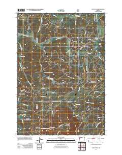
2011 Map of Marys Peak
USGS Topo · Published 2011About this map
Marys Peak anchors this corner of the Coast Range, where high ridges and steep drainages define the landscape of western Benton County. The Marys River and its tributaries, including Clark Creek and Norton Creek, carve through the timbered uplands near the small communities of Blodgett and Alder. Transportation follows the contours of the land, with routes like Marys Peak Rd and Skyline Dr providing access to high-elevation points such as the Marys Peak Observation Point.
Find a feature on this map
50 named features on this map. Tap any name to fly to it.
Don’t see what you’re looking for? This feature index may not catch every label — zoom into the map to look around manually.
Map Details
Editions of this 2011 Marys Peak Map
This is the sole edition of this map. No revisions or reprints were ever made.
Other maps of this area

1921 · Corvallis
USGS Topo · 1:62,500

1922 · Monroe
USGS Topo · 1:62,500

1939 · Marys Peak
USGS Topo · 1:62,500

1939 · Monroe
USGS Topo · 1:62,500

1942 · Marys Peak
USGS Topo · 1:62,500

1942 · Alsea
USGS Topo · 1:62,500

1942 · Monroe
USGS Topo · 1:62,500

1942 · Corvallis
USGS Topo · 1:62,500

1953 · Salem
USGS Topo · 1:250,000

1954 · Salem
USGS Topo · 1:250,000