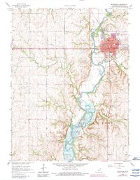
1966 Map of Marysville
USGS Topo · Published 1983About this map
The Big Blue River anchors this Marshall County landscape, winding south from Marysville into the northern reaches of Tuttle Creek Lake. During the mid-1960s, the city served as a primary rail hub with multiple lines of the Union Pacific converging near the town center. The map details a community well-equipped with educational and civic infrastructure, from Lincoln Sch and Central Sch to the St Gregorys Sch. Significant local history is preserved at Alcove Spring, a historic waypoint for travelers, while the industrial and transportation character of the era is evident at the Municipal Airport and the numerous Quarries dotting the bluffs. The transition from the established streets of Marysville to the controlled inundation areas of the reservoir reveals the changing hydrology of the region as the river valley was managed for flood control.
Find a feature on this map
34 named features on this map. Tap any name to fly to it.
Don’t see what you’re looking for? This feature index may not catch every label — zoom into the map to look around manually.
Map Details
Editions of this 1966 Marysville Map
2 editions found
Other maps of this area

1889 · Marysville
USGS Topo · 1:125,000

1894 · Marysville
USGS Topo · 1:125,000

1955 · Manhattan
USGS Topo · 1:250,000

1956 · Manhattan
USGS Topo · 1:250,000

1957 · Manhattan
USGS Topo · 1:250,000

1966 · Oketo
USGS Topo · 1:24,000

1966 · Marysville
USGS Topo · 1:24,000

1966 · Hanover SE
USGS Topo · 1:24,000
1966 · Herkimer
USGS Topo · 1:24,000

1966 · Home
USGS Topo · 1:24,000