
1966 Map of Maryville
USGS Topo · Published 1968About this map
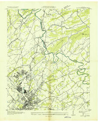
The industrial and institutional heart of Blount County is prominently displayed in this mid-1960s study, anchored by the expansion of Alcoa and the sprawling campus of Maryville College. The urban core of Maryville and its surrounding neighborhoods, including Bungalow Town and Meadow Brook, show significant post-war development reaching toward the Little River. To the west, the infrastructure of the Knoxville Municipal Airport and Mc Ghee Tyson Air Force Base dominates the landscape, while the Southern Railway and Louisville and Nashville Railroad continue to define the regional transport corridors.
Find a feature on this map
96 named features on this map. Tap any name to fly to it.
Don’t see what you’re looking for? This feature index may not catch every label — zoom into the map to look around manually.
Map Details
Editions of this 1966 Maryville Map
This is the sole edition of this map. No revisions or reprints were ever made.
Other maps of this area

1886 · Knoxville
USGS Topo · 1:125,000

1892 · Knoxville
USGS Topo · 1:125,000

1894 · Knoxville
USGS Topo · 1:125,000

1895 · Loudon
USGS Topo · 1:125,000

1895 · Knoxville
USGS Topo · 1:125,000

1901 · Knoxville
USGS Topo · 1:125,000

1935 · Binfield
USGS Topo · 1:24,000

1935 · Knoxville
USGS Topo · 1:48,000
1935 · Maryville
USGS Topo · 1:24,000
1935 · Wildwood
USGS Topo · 1:24,000