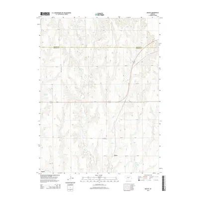
2014 Map of Mascot
USGS Topo · Published 2014About this map
Mascot and the eastern edge of Oxford anchor this rural landscape along the border of Phelps and Harlan counties. The terrain is defined by a dense network of intermittent drainages including Spring Creek, Deep Creek, and Elm Creek, which carve through the agricultural tablelands of south-central Nebraska. Modern water management is evident through the presence of the Cambridge Canal in the southwest and established catchments like Lucking Reservoir and Drake Reservoir. This survey highlights the intersection of local history and infrastructure, preserving the location of family and community landmarks such as Spring Grove Cemetery and Oxford Cemetery. The road network, primarily organized on a section-line grid, is bisected by the prominent diagonal route of Us-34, which serves as a primary artery connecting these high-plains settlements.
Find a feature on this map
33 named features on this map. Tap any name to fly to it.
Don’t see what you’re looking for? This feature index may not catch every label — zoom into the map to look around manually.
Map Details
Editions of this 2014 Mascot Map
This is the sole edition of this map. No revisions or reprints were ever made.
Other maps of this area

1896 · Holdrege
USGS Topo · 1:125,000

1896 · Arapahoe
USGS Topo · 1:125,000

1898 · Arapahoe
USGS Topo · 1:125,000

1955 · Grand Island
USGS Topo · 1:250,000

1957 · Grand Island
USGS Topo · 1:250,000

1958 · Grand Island
USGS Topo · 1:250,000

1958 · Hollinger
USGS Topo · 1:24,000

1958 · Stamford
USGS Topo · 1:24,000

1958 · Mascot
USGS Topo · 1:24,000
1958 · Oxford
USGS Topo · 1:24,000