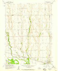
1958 Map of Oxford
USGS Topo · Published 1960About this map
The Republican River valley defines this mid-century landscape, where the town of Oxford serves as a hub for the surrounding agricultural townships. This 1958 survey illustrates the complex water management and transportation systems of the era, from the Cambridge Canal and its intricate series of siphons to the Chicago Burlington and Quincy railroad line running parallel to the river. The map reveals a high density of rural infrastructure, recording the specific locations of several local educational sites including Hardscrabble Sch, Buffalo Sch, and New Era Sch.
Find a feature on this map
23 named features on this map. Tap any name to fly to it.
Don’t see what you’re looking for? This feature index may not catch every label — zoom into the map to look around manually.
Map Details
Editions of this 1958 Oxford Map
This is the sole edition of this map. No revisions or reprints were ever made.
Other maps of this area

1896 · Arapahoe
USGS Topo · 1:125,000

1898 · Arapahoe
USGS Topo · 1:125,000

1955 · Grand Island
USGS Topo · 1:250,000

1957 · Grand Island
USGS Topo · 1:250,000

1958 · Grand Island
USGS Topo · 1:250,000

1958 · Edison
USGS Topo · 1:24,000

1958 · Hollinger
USGS Topo · 1:24,000
1958 · Beaver City
USGS Topo · 1:24,000

1958 · Stamford
USGS Topo · 1:24,000

1958 · Mascot
USGS Topo · 1:24,000