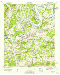
1953 Map of Mascot
USGS Topo · Published 1958About this map
The Holston River carves a winding path through this corner of East Tennessee, defining the boundaries of Knox, Jefferson, and Grainger Counties. The river landscape is dotted with named islands and bends, including McBee Island and Sweet Gum Bend, reflecting a long history of riparian settlement. The Southern Railway runs parallel to the river through Mascot and Strawberry Plains, where industrial and agricultural life intersected.
Find a feature on this map
90 named features on this map. Tap any name to fly to it.
Don’t see what you’re looking for? This feature index may not catch every label — zoom into the map to look around manually.
Map Details
Editions of this 1953 Mascot Map
This is the sole edition of this map. No revisions or reprints were ever made.
Other maps of this area

1886 · Knoxville
USGS Topo · 1:125,000

1892 · Knoxville
USGS Topo · 1:125,000

1894 · Knoxville
USGS Topo · 1:125,000

1895 · Knoxville
USGS Topo · 1:125,000

1897 · Maynardville
USGS Topo · 1:125,000

1900 · Maynardville
USGS Topo · 1:125,000

1901 · Knoxville
USGS Topo · 1:125,000

1935 · Luttrell
USGS Topo · 1:24,000

1935 · Mascot
USGS Topo · 1:24,000

1935 · Knoxville
USGS Topo · 1:48,000