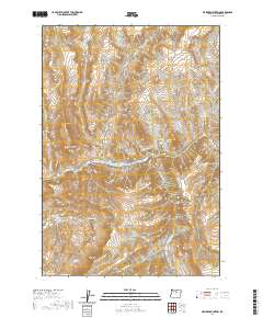
2020 Map of Masiker Mountain
USGS Topo · Published 2020About this map
The John Day River carves a deep path through Wheeler County, defining the central drainage of this central Oregon landscape. This 2020 survey illustrates the complex system of ridges and canyons surrounding the water, where Masiker Mtn and Muleshoe Mtn stand as prominent landmarks. Long-standing local geography is preserved through colorful nomenclature like Hoogie Doogie Mtn and Sourdough Ridge. The map highlights critical water sources for the high desert environment, including Rimrock Spring and Homestead Spring, which have supported ranching and transit for generations. Transportation is limited to rugged tracks like Alder Creek Rd, while the terrain is divided by evocative features such as Solitude Canyon and Starvation Ridge, reflecting the isolation and character of the Oregon interior.
Find a feature on this map
36 named features on this map. Tap any name to fly to it.
Don’t see what you’re looking for? This feature index may not catch every label — zoom into the map to look around manually.
Map Details
Editions of this 2020 Masiker Mountain Map
This is the sole edition of this map. No revisions or reprints were ever made.
Other maps of this area

1926 · Mitchell
USGS Topo · 1:125,000

1953 · Richmond
USGS Topo · 1:62,500

1953 · Spray
USGS Topo · 1:62,500

1955 · Bend
USGS Topo · 1:250,000

1955 · Canyon City
USGS Topo · 1:250,000

1957 · Bend
USGS Topo · 1:250,000

1958 · Bend
USGS Topo · 1:250,000

1959 · Canyon City
USGS Topo · 1:250,000

1966 · Mitchell
USGS Topo · 1:62,500

1966 · Kinzua
USGS Topo · 1:62,500