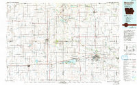
1985 Map of Mason City
USGS Topo · Published 1992About this map
Mason City and the neighboring shoreline of Clear Lake serve as the primary hubs in this 1980s landscape, where the prairie grid of northern Iowa meets an extensive system of conservation lands. The map illustrates a region defined by its water and wildlife management, including the large Pilot Knob State Park and numerous specialized tracts like the Elk Creek Marsh State Wildlife Management Area and Harmon Lake State Wildlife Management Area.
Find a feature on this map
113 named features on this map. Tap any name to fly to it.
Don’t see what you’re looking for? This feature index may not catch every label — zoom into the map to look around manually.
Map Details
Editions of this 1985 Mason City Map
2 editions found
Other maps of this area

1954 · Albert Lea
USGS Topo · 1:62,500

1954 · Hayward
USGS Topo · 1:62,500

1954 · Austin
USGS Topo · 1:62,500

1954 · Fairmont
USGS Topo · 1:250,000

1954 · Mason City
USGS Topo · 1:250,000

1954 · Waterloo
USGS Topo · 1:250,000

1954 · Fort Dodge
USGS Topo · 1:250,000

1955 · Waterloo
USGS Topo · 1:250,000

1955 · Bricelyn
USGS Topo · 1:62,500

1955 · Wells
USGS Topo · 1:62,500