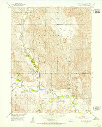
1951 Map of Mason City SE
USGS Topo · Published 1953About this map
The South Loup River winds through the southern reaches of this Nebraska landscape, defining the transition between Harrison and Sartoria townships. This 1951 field-checked survey reveals a rural community supported by a dense network of country schoolhouses, including Tufford Sch, Black Hill Basin Sch, Pilot Sch, and Black Hill Creek Sch. These institutions, alongside the Salem Ch and Elk Creek Cem, anchor the social geography of the era, reflecting a period when small, localized school districts were still the standard for the area's farming families.
Find a feature on this map
17 named features on this map. Tap any name to fly to it.
Don’t see what you’re looking for? This feature index may not catch every label — zoom into the map to look around manually.
Map Details
Editions of this 1951 Mason City SE Map
3 editions found
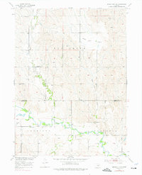
Other maps of this area

1896 · Kearney
USGS Topo · 1:125,000

1951 · Litchfield SW
USGS Topo · 1:24,000

1951 · Mason City SW
USGS Topo · 1:24,000

1951 · Mason City NW
USGS Topo · 1:24,000

1951 · Mason City
USGS Topo · 1:24,000

1951 · Mason City SE
USGS Topo · 1:24,000

1951 · Litchfield
USGS Topo · 1:24,000

1955 · Broken Bow
USGS Topo · 1:250,000

1955 · Grand Island
USGS Topo · 1:250,000

1956 · Broken Bow
USGS Topo · 1:250,000