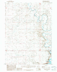
1987 Map of Massacre Hill
USGS Topo · Published 1987About this map
Massacre Hill overlooks the high-desert drainages of southwestern Wyoming in this 1980s provisional study. The landscape is defined by the winding course of the Blacks Fork, which meanders through the northern and eastern portions of the quadrangle before feeding into the northern reaches of the Flaming Gorge Reservoir. This hydrologic transition marks a significant moment in the region's geography, where natural watercourses like Little Dry Creek and Chicken Draw meet the managed waters of the Flaming Gorge National Recreation Area.
Find a feature on this map
11 named features on this map. Tap any name to fly to it.
Don’t see what you’re looking for? This feature index may not catch every label — zoom into the map to look around manually.
Map Details
Editions of this 1987 Massacre Hill Map
This is the sole edition of this map. No revisions or reprints were ever made.
Other maps of this area

1954 · Rock Springs
USGS Topo · 1:250,000

1957 · Mc Kinnon Junction
USGS Topo · 1:62,500

1958 · Rock Springs
USGS Topo · 1:250,000

1961 · Little America
USGS Topo · 1:24,000

1961 · Peru
USGS Topo · 1:24,000

1961 · Bryan
USGS Topo · 1:24,000

1962 · Rock Springs
USGS Topo · 1:250,000

1964 · Antelope Knoll NE
USGS Topo · 1:24,000

1964 · Winter Fat Reservoir
USGS Topo · 1:24,000

1966 · Mc Kinnon Junction
USGS Topo · 1:62,500