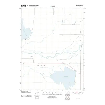
2010 Map of Masters
USGS Topo · Published 2010About this map
The South Platte River carves a central path through this landscape, defining an area heavily shaped by water management and irrigation. Located in Colorado, this 2010 survey highlights the intricate network of the Bijou Canal, Empire Intake Canal, and the Jackson Lake Inlet, which facilitate agricultural life in the semi-arid High Plains. Significant water bodies like the Riverside Reservoir and the Empire Reservoir, held by the Riverside Dam and Empire Dam respectively, dominate the northern and southern portions of the map. The small settlement of Masters and the Masters Post Office serve as the primary human centers, while the Yocam Ranch Airport indicates the role of private aviation in managing these large ranching and farming operations. Nearby Green City Flats and the community of Sublette further illustrate the sparse but deliberate distribution of homesteads and infrastructure across the Weld County terrain.
Find a feature on this map
34 named features on this map. Tap any name to fly to it.
Don’t see what you’re looking for? This feature index may not catch every label — zoom into the map to look around manually.
Map Details
Editions of this 2010 Masters Map
This is the sole edition of this map. No revisions or reprints were ever made.
Other maps of this area

1950 · Wiggins
USGS Topo · 1:24,000

1950 · Greasewood Lake
USGS Topo · 1:24,000

1950 · Masters
USGS Topo · 1:24,000

1951 · Masters
USGS Topo · 1:24,000

1951 · Orchard
USGS Topo · 1:24,000

1951 · Roggen
USGS Topo · 1:24,000

1951 · Sunken Lake
USGS Topo · 1:24,000

1951 · Omar
USGS Topo · 1:24,000

1951 · Point Of Rocks
USGS Topo · 1:24,000
1951 · Dearfield
USGS Topo · 1:24,000