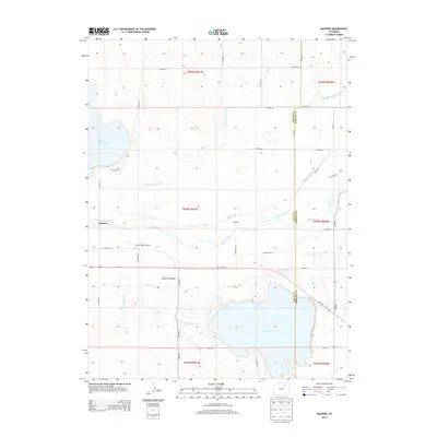
2013 Map of Masters
USGS Topo · Published 2013About this map
Empire Reservoir dominates the southern landscape of this 2013 survey, anchoring a complex system of irrigation infrastructure in Weld and Morgan counties. The S Platte River bisects the terrain, flanked by the small settlements of Masters and Sublette. This region is defined by its extensive water management network, which includes the Riverside Intake Canal, Bijou Canal, and the Weldon Valley Ditch, all essential to the agricultural viability of the Green City Flats. The presence of the Yocam Ranch Airport and the large Riverside Reservoir to the northwest highlights the dual nature of the land, serving both as a hub for local aviation and a critical water storage area for the surrounding High Plains farms. Researchers can trace the section lines and rural road networks, such as CO Road 52 and Us-34 E, which provide the structural backbone for the dispersed homesteads and ranches in this part of eastern Colorado.
Find a feature on this map
41 named features on this map. Tap any name to fly to it.
Don’t see what you’re looking for? This feature index may not catch every label — zoom into the map to look around manually.
Map Details
Editions of this 2013 Masters Map
This is the sole edition of this map. No revisions or reprints were ever made.
Other maps of this area

1950 · Wiggins
USGS Topo · 1:24,000

1950 · Greasewood Lake
USGS Topo · 1:24,000

1950 · Masters
USGS Topo · 1:24,000

1951 · Masters
USGS Topo · 1:24,000

1951 · Orchard
USGS Topo · 1:24,000

1951 · Roggen
USGS Topo · 1:24,000

1951 · Sunken Lake
USGS Topo · 1:24,000

1951 · Omar
USGS Topo · 1:24,000

1951 · Point Of Rocks
USGS Topo · 1:24,000
1951 · Dearfield
USGS Topo · 1:24,000