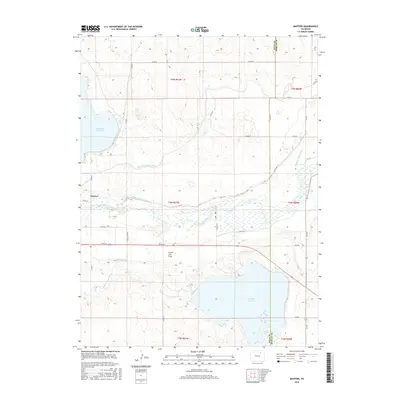
2016 Map of Masters
USGS Topo · Published 2016About this map
Masters sits as the central point of interest in this agricultural and water-management landscape along the South Platte River. The area is defined by a complex network of irrigation infrastructure essential to the high plains, including the Bijou Canal, Riverside Intake Canal, and the Weldon Valley Ditch. Large-scale water storage dominates the terrain, with Riverside Reservoir in the northwest and Empire Reservoir spanning the southern border near the Weld County and Morgan County line. These reservoirs and the Jackson Lake Inlet reflect the engineered hydrology required to sustain the region's farms. Between these water bodies lies Green City Flats, a notable terrain feature that illustrates the natural basin topography of the river valley. The map provides a clear look at the intersection of county roads and water routes that have shaped this portion of the Colorado plains.
Find a feature on this map
35 named features on this map. Tap any name to fly to it.
Don’t see what you’re looking for? This feature index may not catch every label — zoom into the map to look around manually.
Map Details
Editions of this 2016 Masters Map
This is the sole edition of this map. No revisions or reprints were ever made.
Other maps of this area

1950 · Wiggins
USGS Topo · 1:24,000

1950 · Greasewood Lake
USGS Topo · 1:24,000

1950 · Masters
USGS Topo · 1:24,000

1951 · Masters
USGS Topo · 1:24,000

1951 · Orchard
USGS Topo · 1:24,000

1951 · Roggen
USGS Topo · 1:24,000

1951 · Sunken Lake
USGS Topo · 1:24,000

1951 · Omar
USGS Topo · 1:24,000

1951 · Point Of Rocks
USGS Topo · 1:24,000
1951 · Dearfield
USGS Topo · 1:24,000