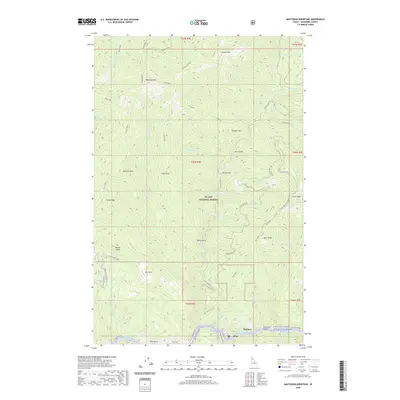
2020 Map of Mastodon Mountain
USGS Topo · Published 2020About this map
The St. Joe River carves through the southern edge of this Idaho mountain landscape, designated here as the Saint Joe Wild and Scenic River. Small settlements such as Hoyt and Ethelton cling to the narrow river valley, which serves as a primary transit corridor via the St Joe River Rd. This area within the St. Joe National Forest is defined by its high summits and deep drainages, including Mastodon Mtn, Dunn Peak, and Prince Peak. The modern era has introduced specialized access for backcountry exploration, evidenced by numerous designated off-highway vehicle routes like Dunn Peak Ohv and Lower Dennis Ohv. These trails often follow older service paths to landmarks such as the Dunn Peak Lookout Ohv, while names like Daisy Gulch, Horn Gulch, and Ally Point speak to the long history of land navigation in Shoshone County.
Find a feature on this map
60 named features on this map. Tap any name to fly to it.
Don’t see what you’re looking for? This feature index may not catch every label — zoom into the map to look around manually.
Map Details
Editions of this 2020 Mastodon Mountain Map
This is the sole edition of this map. No revisions or reprints were ever made.
Other maps of this area

1914 · Avery
USGS Topo · 1:125,000

1917 · Avery
USGS Topo · 1:125,000

1955 · Spokane
USGS Topo · 1:250,000

1956 · Wallace
USGS Topo · 1:250,000

1957 · Wallace
USGS Topo · 1:62,500

1957 · Calder
USGS Topo · 1:62,500

1958 · Spokane
USGS Topo · 1:250,000

1960 · Wallace
USGS Topo · 1:250,000

1969 · Marble Mountain
USGS Topo · 1:24,000
1969 · Hoyt Mountain
USGS Topo · 1:24,000