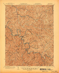
1928 Map of Matewan
USGS Topo · Published 1945About this map
Tug Fork carves a serpentine boundary between West Virginia and Kentucky, serving as the central artery for the coal-driven economy of the late 1920s. This survey, revised just before the turn of the decade, documents the intensive industrial footprint of the Norfolk and Western railroad as it follows the river's path. The landscape is a dense network of mining operations and supporting company towns, from the established Matewan to the operations at Puritan Mines and Thacker Mines.
Find a feature on this map
135 named features on this map. Tap any name to fly to it.
Don’t see what you’re looking for? This feature index may not catch every label — zoom into the map to look around manually.
Map Details
Editions of this 1928 Matewan Map
4 editions found
Other maps of this area

1886 · Grundy
USGS Topo · 1:125,000

1887 · Warfield
USGS Topo · 1:125,000

1890 · Grundy
USGS Topo · 1:125,000

1891 · Tazewell
USGS Topo · 1:125,000

1891 · Oceana
USGS Topo · 1:125,000

1891 · Warfield
USGS Topo · 1:125,000

1892 · Grundy
USGS Topo · 1:125,000

1893 · Oceana
USGS Topo · 1:125,000

1895 · Tazewell
USGS Topo · 1:125,000

1897 · Tazewell
USGS Topo · 1:125,000