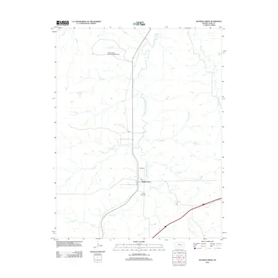
2012 Map of Matfield Green
USGS Topo · Published 2012About this map
Matfield Green sits as the central settlement in this Chase County landscape, where the S Fork Cottonwood River draws a serpentine path through the Flint Hills. The map documents a predominantly agrarian environment defined by a dense network of drainage, including Little Cedar Cr, Crocker Cr, and Sharpes Cr. A significant cultural landmark, the Knute Rockne Memorial Monument, is located near the northern edge of the survey, marking the site of the 1931 plane crash that claimed the legendary Notre Dame coach. Local genealogy and history are preserved at the Matfield Green Cem and through named thoroughfares like Rogler St and Evans St, which reflect the families who established this cattle-ranching region.
Find a feature on this map
19 named features on this map. Tap any name to fly to it.
Don’t see what you’re looking for? This feature index may not catch every label — zoom into the map to look around manually.
Map Details
Editions of this 2012 Matfield Green Map
This is the sole edition of this map. No revisions or reprints were ever made.
Other maps of this area

1888 · Emporia
USGS Topo · 1:125,000

1894 · Emporia
USGS Topo · 1:125,000

1898 · Cottonwood Falls
USGS Topo · 1:125,000

1955 · Hutchinson
USGS Topo · 1:250,000

1957 · Elmdale
USGS Topo · 1:24,000

1959 · Hutchinson
USGS Topo · 1:250,000
1967 · Teterville
USGS Topo · 1:24,000
1967 · Cassoday
USGS Topo · 1:24,000
1967 · Matfield Green SE
USGS Topo · 1:24,000

1973 · Matfield Green
USGS Topo · 1:24,000