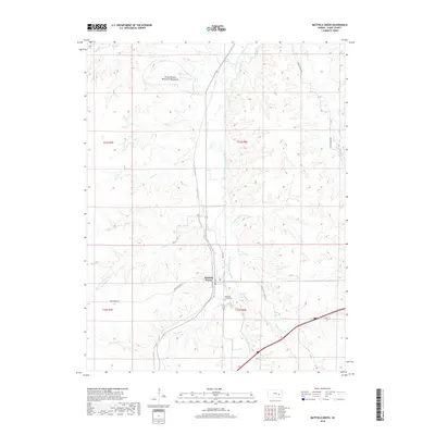
2018 Map of Matfield Green
USGS Topo · Published 2018About this map
Matfield Green serves as the central hub of this prairie landscape, where the South Fork Cottonwood River meanders through the Flint Hills. The town is flanked by numerous watercourses, including Kirk Cr, Steak Bake Cr, and Crocker Cr, illustrating a topography defined by drainage and ranching corridors. A significant cultural landmark, the Knute Rockne Memorial Monument, stands near Baker Cr in the northern portion of the quadrangle, marking the site of the 1931 plane crash that killed the legendary football coach. Local history is further preserved at the Matfield Green Cem located just south of the main settlement. Roadways such as Open Range Rd and 78 Rd hint at the rural infrastructure supporting the region's agricultural traditions and sparse residential patterns.
Find a feature on this map
28 named features on this map. Tap any name to fly to it.
Don’t see what you’re looking for? This feature index may not catch every label — zoom into the map to look around manually.
Map Details
Editions of this 2018 Matfield Green Map
This is the sole edition of this map. No revisions or reprints were ever made.
Other maps of this area

1888 · Emporia
USGS Topo · 1:125,000

1894 · Emporia
USGS Topo · 1:125,000

1898 · Cottonwood Falls
USGS Topo · 1:125,000

1955 · Hutchinson
USGS Topo · 1:250,000

1957 · Elmdale
USGS Topo · 1:24,000

1959 · Hutchinson
USGS Topo · 1:250,000
1967 · Teterville
USGS Topo · 1:24,000
1967 · Cassoday
USGS Topo · 1:24,000
1967 · Matfield Green SE
USGS Topo · 1:24,000

1973 · Matfield Green
USGS Topo · 1:24,000