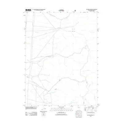
2012 Map of Mattier Creek
USGS Topo · Published 2012About this map
Lambert Ranch, Mattier Ranch, and Magnuson Ranch anchor this high-desert landscape in White Pine County, showing the persistent ranching operations that define this region. The water system is characterized by seasonal drainages and essential springs, including Sliderock Spring and Teapot Spring, which support livestock and wildlife in an arid environment. The road network connects these remote stations via Old Hwy 93 and several Forest Service routes like NFD 488 RD. Notable drainages such as Mattier Cr and Big Indian Cr carve through the basin, while Dry Canyon and the surrounding slopes of the northern Shell Creek Range provide significant relief. The presence of the Eera One Hundred Three marker and various cattle-related infrastructure points to the ongoing agricultural utility of this Great Basin terrain.
Find a feature on this map
25 named features on this map. Tap any name to fly to it.
Don’t see what you’re looking for? This feature index may not catch every label — zoom into the map to look around manually.
Map Details
Editions of this 2012 Mattier Creek Map
This is the sole edition of this map. No revisions or reprints were ever made.
Other maps of this area

1956 · Ely
USGS Topo · 1:250,000

1959 · Ely
USGS Topo · 1:250,000

1963 · Ely
USGS Topo · 1:250,000
1982 · Kalamazoo Creek
USGS Topo · 1:24,000

1982 · Borchert Spring
USGS Topo · 1:24,000
1982 · Monte Neva Hot Springs
USGS Topo · 1:24,000
1982 · Silver Canyon
USGS Topo · 1:24,000
1982 · Stonehouse
USGS Topo · 1:24,000
1982 · Steptoe
USGS Topo · 1:24,000
1982 · Schellbourne
USGS Topo · 1:24,000