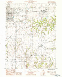
1984 Map of Mattoon East
USGS Topo · Published 1985About this map
Mattoon and its surrounding countryside are captured here in the mid-1980s, revealing a landscape defined by industrial expansion and rural continuity. The eastern reaches of the city meet the agricultural expanses of Lafayette and Pleasant Grove, where smaller outposts like Lerna, Loxa, and Trilla dot the rail corridors. Transportation infrastructure is a dominant theme, with the Illinois Central Gulf and Conrail lines carving through the prairie, supporting the regional economy alongside the Coles County Memorial Airport. Significant local landmarks include a Drive-In Theater and a Nature Preserve, contrasting mid-century entertainment with environmental conservation. The drainage patterns of Kickapoo Creek and Indian Fk Creek provide the primary relief to the otherwise level Illinois terrain, illustrating how these waterways dictated early settlement and land use across the county line near Charleston.
Find a feature on this map
28 named features on this map. Tap any name to fly to it.
Don’t see what you’re looking for? This feature index may not catch every label — zoom into the map to look around manually.
Map Details
Editions of this 1984 Mattoon East Map
This is the sole edition of this map. No revisions or reprints were ever made.
Other maps of this area

1933 · Toledo
USGS Topo · 1:62,500

1934 · Mattoon
USGS Topo · 1:62,500

1935 · Arcola
USGS Topo · 1:48,000

1936 · Oakland
USGS Topo · 1:48,000

1937 · Mattoon
USGS Topo · 1:62,500

1938 · Toledo
USGS Topo · 1:62,500

1940 · Arcola
USGS Topo · 1:62,500

1942 · Oakland
USGS Topo · 1:62,500

1958 · Decatur
USGS Topo · 1:250,000

1961 · Decatur
USGS Topo · 1:250,000